
ID: 147
Closed
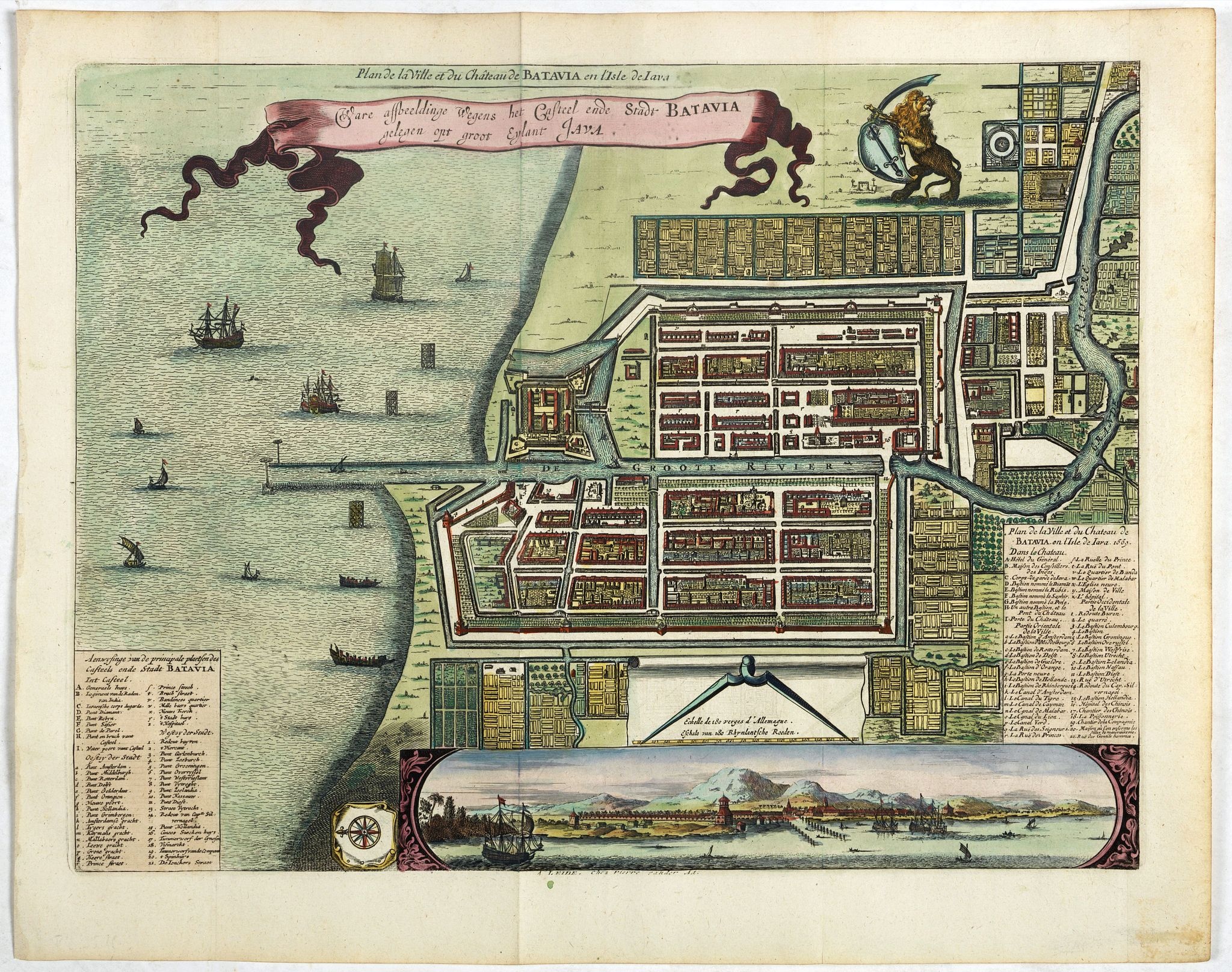
Ware affbeeldinge wegens het casteel ende stadt Batavia. . .
BuyNow for $800
- Maker :
- VANDER AA, P.
- Place :
- Leiden
- Date :
- 1719
- Color :
- Colored
- Height mm.:
- 265
- Width mm.:
- 355
- Condition :
- In good condition. Very dark impression. Paper very slightly age toned.
- Bibliography :
- -
- Seller's ref. :
- 38349
This item is offered by Paulus_Swaen_Old_Maps
See other Items from this seller- Postage
-
Europe
$34 to France
- Select Country
- Zip/Post Code
- Quantity
$800
Description
A reduced version of Clement de Jonghe (1650) plan of Jakarta from 1650. The town plan has a vignette at the bottom showing Jakarta from the sea with the volcanoes Mount Gede, Mount Pangrnago and Mount Salak in the background.Engraved for Arnoldus Montanus "Gedenkwaerdige gesantschappen der Oost-Indische maatschappy in ’t Vereenigde Nederland. . ." (1669) but reissued by Pieter van der AA.
Batavia, present-day Jakarta, the Dutch center of trading activities in the East Indies. European and native ships are shown in the sea, while the Dutch lion stands proudly above the schematically planned city.

Inverted nautical Compass, called "mouchard" (~ "spy-glass")
Inverted maritime compass called "mouchard" (spy) in wood and brass, signed "A Van Vastenhoud In Amsterdam". This type of compass was found in the captain's cabin and hanging above the captain's bed. The captain was so able to see the direction when he was in his cabin. This example is mounted in a wooden box to keep it safe. The compass itself is mounted on brass gimbals to keep it steady on a moving ship. It has a single iron needle with a brass cap that rests on a spike projecting from the bo...
$7.500
Maker : VAN VASTENHOUD, A.
Place : Amsterdam
Date : ca. 1780

Beschrijvinge vande de zee Cuften va Vlanderen en Picardien. . .
DUTCH TEXT EDITION. A detailed chart of the coast of Flanders and Normandy decorated by a large colorful baroque title cartouche, and the coat of arms of Flanders with a colorful scale cartouche decorated with a compass, a compass rose, several vessels and sea monsters. From an early Dutch text edition of this landmark contribution to the science of navigation. Waghenaer's own personal experiences as a pilot along European coasts were used to compile the Spiegel der Zeevaerdt, the first edition ...
$3.000
Maker : WAGHENAER, L. J.
Place : Leiden, Plantijn
Date : 1585

Freedom of the Air.
A world map packed with information about aviation and the aluminum industry.The use of aircraft in warfare, especially in the roles of close ground support and strategic bombing, was completely revolutionized during WWII. Apart from tactics, the technology also evolved to facilitate heavier bombers, faster fighters, more capable transports and greater range all-around. One critical component of this development was using light, flexible and sturdy aluminum frames and skins for the planes, rathe...
$230
Maker : ALCOA ALUMINUM COMPANY.
Place : United-States
Date : 1943

Kaerte en Afbeeldinge vande Geheele Jurisdictie van Stantdarbuyten Gelegen in de Generaliteit onder Marquisaet van Bergen op den Zoom
With a large title cartouche with signature of the maker Adriaan van der Ende, : Kaerte en Afbeeldinge vande Geheele Jurisdictie van Stantdarbuyten Gelegen in de Generaliteit onder Marquisaet van Bergen op den Zoom, gemaekt, en in den Jare van 1733, 1734, 1735 gemeten by my ondergetz… Willemstadt den 8 Julij 1737 Adr: van Enden.Adriaan van de Ende was a surveyor, appointed by the Council of Brabant in 1720, then living in Heyningen. Was later living and active in Willemstad.Other manuscript m...
$2.500
Maker : VAN DE ENDEN, A.
Place : Willemstadt
Date : 1737
Postage & Shipping
-
Item Location
Terms and conditions - Item Location
- Paris, Ile-de-France, France
- Ships To
- United States, United Kingdom, Albania, Argentina, Armenia, Australia, Azerbaijan, Bahamas, Belgium, Bermuda, Cambodia, Canada, Chile, China, Croatia, Cyprus, Czech Republic, Denmark, Estonia, Finland, France, Germany, Gibraltar, Greece, Greenland, Guatemala, Hong Kong, Iceland, India, Indonesia, Israel, Italy, Japan, Latvia, Lithuania, Luxembourg, Malta, Mexico, Monaco, Netherlands, Norway, Singapore, Spain, Sweden, Switzerland, Turkey
- Pick-ups
- No pick-ups
This item is owned and offered by the seller Paulus_Swaen_Old_Maps - All items are available for immediate sale, offered subject to prior sale.
Invoices are created by the seller by using our shopping cart or be prepared by the seller the day following the order and are emailed to you.
Items offeres by different sellers are invoiced separately.
Shipping fees are extra. The buyer is responsible for all applicable taxes, including any VAT, customs clearance, import duties, or equivalent costs arriving at the customer's home border. Payment is due on receipt of the invoice. The item(s) are shipped as soon as possible after receipt of your payment.
Before buying please read the complete Terms Conditions of Sale.
- Payment Methods
- Visa, Mastercard, Bank Transfer, American Express, iDEAL, PayPal
- Returns Accepted
- No
Post Message
Feel free to ask the seller a question. Please note that the seller could be located in an area with a different time zone. Our seller will do their best to respond within 24 hours.Post your message below.
Sign in to ask the seller a question.
