
ID: 161
Open
Listing ID: #161 has been added to your wishlist.
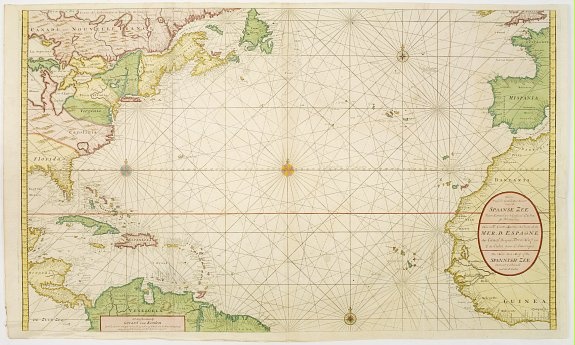
Nieuwe Wassende Graade Zee Kaart over de Spaanse Zee Vant Kanaal tot 't Eyland Cuba in Westindia. . .
BuyNow for $3.000
- Maker :
- VAN KEULEN, G.
- Place :
- Amsterdam
- Date :
- 1728
- Color :
- Colored
- Height mm.:
- 583
- Width mm.:
- 975
- Condition :
- Printed from two plates. Repair of a tear next to crossing of two folds, hardly notable.
- Bibliography :
- Koeman: Atlantes Neerlandici, Vol.IV, (212).
- Seller's ref. :
- 00018
This item is offered by Paulus_Swaen_Old_Maps
See other Items from this seller- Postage
-
Standard Shipping
$0 to France
- Select Country
- Zip/Post Code
- Quantity
$3.000
Description
¤ Engraved by I.van Anse. A very representative example of a Dutch chart of the Atlantic, showing the north-east coast of America, the coasts of Africa and Europe and South America, including Florida and the West Indies.Gerard issued ca. 40 charts of this exceptionally large format. Collections of these large-size charts were issued in the shining sea-torch and as separate atlases.

Very rare share in the Ostend Company. (4527)
Upper left hand corner share number 4527 in manuscript. In top emblem of the Ostend Company in copper engraving. Text: De Directeurs van de generale Keijserlijche- Indische compagnie, ordoneren aen hunnen cassier 'joan Baptist Cogels junior, te ontvangen van D'Heer Ferdinand Anthoin Baron de Veecquemans, Antwerp. de somme van tweehondert en vijftigh guldens wisselgeldt, voor het eerste payement sijnder actie van een duijsent guldens in het Capitael van de Selve compagnie, op de conditien in het ...
$2.000
Maker : OSTEND COMPANY
Place : Antwerp / Ostend
Date : 1723

Amsterdam Ville du comté de Hollande. . .
A very decorative and very rare town view of Amsterdam, including a numbered key ( A- T) in the lower part. Engraved by Pierre-Alexandre Aveline. With the signature "Aveline avec privil. du Roy" in the lower right margin. Pierre Aveline (Paris, c.1656 - 23 May 1722), was an engraver, print-publisher and print-seller. He probably trained with Adam Pérelle and specialized in topographical representations like him. He engraved in suites many views of Paris and of provincial, European and African c...
$500
Maker : AVELINE, P.A.
Place : Paris
Date : 1692
![[Cavendish reaches Morro Moreno.]](/uploads/cache/39910-500x500.jpg)
[Cavendish reaches Morro Moreno.]
Scarce print with a German text sheet showing Cavendish’s fleet anchor at a place called Morro Moreno, on the coast of Chile. The Indians came down from the high cliffs to greet the voyagers and brought with them firewood and fresh water as a sign of friendship. Later the English were taken to their homes, which were made from two sticks in the ground, with others laid across and covered with straw. The whole family, including children, lay underneath on animal skins. They were skilled fisherm...
$80
Maker : GOTTFRIED, J.L. / DE BRY.
Place : Frankfurt, M.Merian
Date : 1633

Brabantia.
A lovely miniature map of the Duchy of Brabant, published by Petrus Bertius, in Amsterdam at the beginning of the seventeenth century. There is a nice, small strap-work title, a little stippled sea, and the map depicts local topography and towns including Mechelen, Breda, Cleve, Maestricht, Cologne, Brussels and Namur. This example is from the Tabularum Geographicarum Contractarum. Bertius (1565-1629) was a Flemish cartographer, theologian, historian and geographer. Although he published much in...
$100
Maker : LANGENES, B. / BERTIUS, P.
Place : Amsterdam, 1606
Date : 1606
Postage & Shipping
-
Item Location
Terms and conditions - Item Location
- 75013, Ile-de-France, France
- Ships To
- United States, United Kingdom, Albania, Argentina, Armenia, Australia, Azerbaijan, Bahamas, Belgium, Bermuda, Cambodia, Canada, Chile, China, Croatia, Cyprus, Czech Republic, Denmark, Estonia, Finland, France, Germany, Gibraltar, Greece, Greenland, Guatemala, Hong Kong, Iceland, India, Indonesia, Israel, Italy, Japan, Latvia, Lithuania, Luxembourg, Malta, Mexico, Monaco, Netherlands, Norway, Singapore, Spain, Sweden, Switzerland, Turkey
- Pick-ups
- No pick-ups
This item is owned and offered by the seller Paulus_Swaen_Old_Maps - All items are available for immediate sale, offered subject to prior sale.
Invoices are created by the seller by using our shopping cart or be prepared by the seller the day following the order and are emailed to you.
Items offeres by different sellers are invoiced separately.
Shipping fees are extra. The buyer is responsible for all applicable taxes, including any VAT, customs clearance, import duties, or equivalent costs arriving at the customer's home border. Payment is due on receipt of the invoice. The item(s) are shipped as soon as possible after receipt of your payment.
Before buying please read the complete Terms Conditions of Sale.
- Payment Methods
- Visa, Mastercard, Bank Transfer, American Express, iDEAL, PayPal, Google Pay
- Returns Accepted
- No
Post Message
Feel free to ask the seller a question. Please note that the seller could be located in an area with a different time zone. Our seller will do their best to respond within 24 hours.Post your message below.
Sign in to ask the seller a question.
