ID: 103
Open
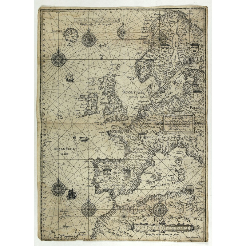
Universe Europae Maritime Eiusque Navigationis Descriptio. Generale Pascaerte van Europa . . .
£14.290
- Quantity
- 1
- Postage
-
£0 to United States
Standard Shipping
Get Additional Rates
- Select Country
- Zip/Post Code
- Quantity
£14.290
84 watching
621 views
Description
This general chart of north-western Europe and the surrounding coastal waters is from the rare pilot-guide De Spiegel der Zeevaerdt , printed by Christopher Plantin in Leyden.
FIRST PLATE AND FIRST STATE, which appeared in the first 3 editions, before Latin names of some seas and inscriptions in the scale bars were added. (editions 4-12). EXTREMELY RARE.
Engraved by Johannes van Doeticum, and embellished with ships and overlaid with directional rhumbs radiating from decorative compass roses typical of portolan charts which were no doubt sources for this map. The scalloped design of the shores is also characteristic of the portolans. In the land part the coast-of-arms of the various European countries.
FIRST PLATE AND FIRST STATE, which appeared in the first 3 editions, before Latin names of some seas and inscriptions in the scale bars were added. (editions 4-12). EXTREMELY RARE.
The map's title is given in both Latin and Dutch, with the latter attributing it to Waghenaer and nothing a privilege of ten years. The date 1583 is engraved in a box capping the title cartouche. The chart is signed "Ioannes à Doetecum". It may have been that Waghenaer had already sold this portolan chart in 1579.
The place names are written inland continuously around the coast from north to south, in order to facilitate the navigator's readings accomplished by rotating the map.
Specifications
- Your stock number
- -
- Maker / Publisher
- WAGHENAER, L.J.
- Place
- Leyden, 1584
- Date
- Leyden, 1584
- Color
- Uncoloured
- Height
- 605
- Width
- 525
- Condition
- Dutch text on verso. Some browning, foxing. A few worm holes filled in. The Europe chart is larger than the other charts in the atlas, as often the case the lower margin is trimmed affecting part of the grade scale. Dark impression.
- Reference
- Koeman Wag 1 B.
Payments & Returns
- Payment Methods
- Visa, Mastercard, Bank Transfer
Postage & Shipping
- Item Location
- Amsterdam, Alabama, United States
- Ships To
- United States, United Kingdom, Albania, Argentina, Armenia, Australia, Azerbaijan, Bahamas, Belgium, Bermuda, Cambodia, Canada, Chile, China, Croatia, Cyprus, Czech Republic, Denmark, Estonia, Finland, France, Germany, Gibraltar, Greece, Greenland, Guatemala, Hong Kong, Iceland, India, Indonesia, Israel, Italy, Japan, Latvia, Lithuania, Luxembourg, Malta, Mexico, Monaco, Netherlands, Norway, Singapore, Spain, Sweden, Switzerland, Turkey
- Pick-ups
- No pick-ups
- Returns Accepted
- No
Post Message
Sign in to ask the seller a question.
Paulus_Swaen
Arcenal de l'Amirauté.
A decorative print of the 'T Landts Magazyn , or 'Scheepvaart Museum' (Naval Museum).
£60
Paulus_Swaen
Calendrier de la cour, tiré des éphémérides, pour l'Année bissextile.. / Notebook bearing silver plates with the VOC monogram.
A personal gift, only made for the trustees of the V.O.C. The silver plate was probably made by Drick van Hengel and Company because an entry in the diary of mintmaster Johann Georg Holtzhey for the years 1777-1784 reveals that silver work for book clasps for the Delft and Rotterdam chambers was to be supplied by Dirck van Hengel and Company on a yearly basis.The almanac contains a list of the daily sun rise and sun set, the phases of the moon, etc. Jacques Collombat (Grenoble, circa 1668 - idem...
£3.385
Paulus_Swaen
Flaggen aller seefahrenden potenzen und nationen…
A highly decorative and beautiful print with 139 flags of the sea-faring nations, factions, and trading companies. Among the more interesting flags are those of the Dutch West India Company (G.WC. /Geoctroyeerde Westindische Compagnie) and the Dutch East India Company (V.O.C. / Vereenigde Oostindische Compagnie). This plate is probably derived from a Dutch flag print issued by Cornelis Danckerts c. 1700.
£752
Paulus_Swaen
Britain's Empire on the Sea. Dedicated to Captain the Right Honourable Lord Charles Beresford...
A very decorative and large chromolithographed plate showing all the effective strength of the British navy with the name and class of each ship shown beneath, except for the torpedo boats destroyers denoted by numbers.The pate is dedicated to the Right Honourable Lord Charles William de la Poer Beresford (10 February 1846 – 6 September 1919). He was a British admiral and Member of Parliament. He combined the two careers of the navy and a member of parliament, making a reputation as a hero in ...
£752


-500x500.jpg)


