ID: 133
Open
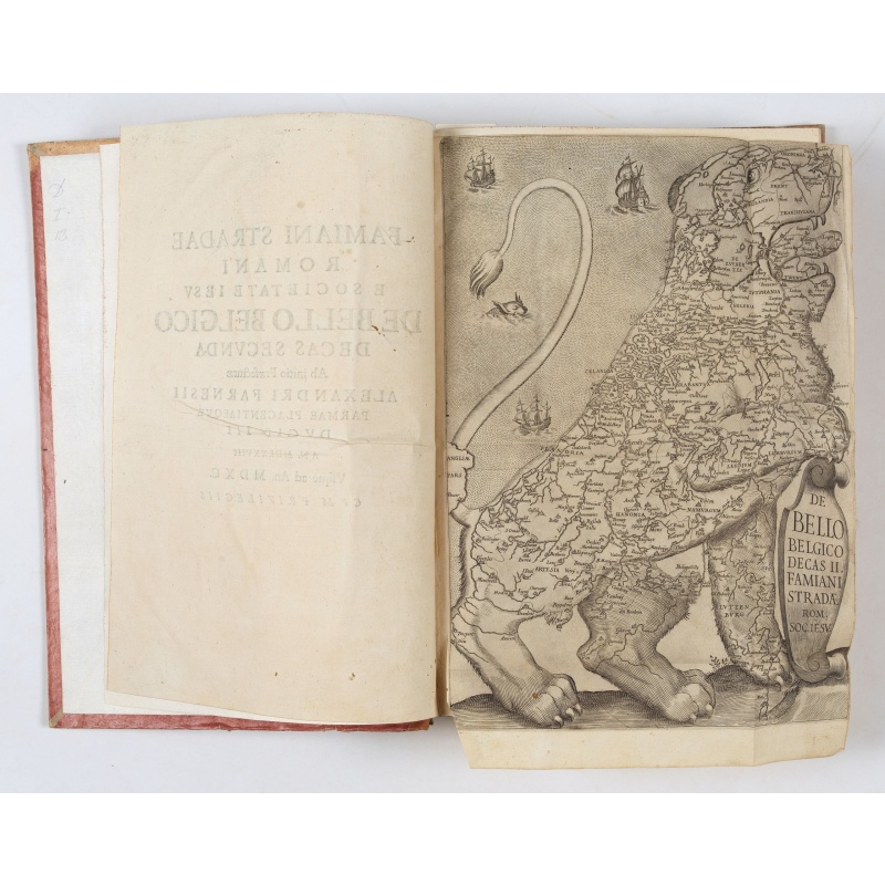
De Bello Belgico, Decas Prima / Decas Secunda.
BuyNow for €6.900
- Maker :
- STRADA, Famiano.
- Place :
- Rome, Franciscus Corbelletus
- Date :
- 1632-1647
- Color :
- Uncoloured
- Height mm.:
- 325
- Width mm.:
- 225
- Condition :
- 2 vols. Folio. Pink cardboards, basane on spine, gilt-tooled title and fillets, red sprinkled edges. Boards partly faded. Maps folded. A few engravings cut till plate mark.
- Bibliography :
- -
- Seller's ref. :
- 48779
This item is offered by Librairie_Loeb-Larocque
See other Items from this seller- Postage
-
Standard Shipping
€0 to France
- Select Country
- Zip/Post Code
- Quantity
€6.900
Description
With 2 engraved titles of the 'Leo Belgicus', with one paw resting on a shield bearing the title, large woodcut printer's device on the colophons, and 30 richly engraved views and plans of battles and sieges, 28 double-page and 2 full-page, by Johanness W.Bauer, J.Miele, Jacomo Cortese, a.o.Two examples of the famous Leo Belgicus map are included. Among the greatest decorative works of early cartography is a series of arresting maps showing The Netherlands and Belgium in the shape of a lion.
Aniou. . .
Decorative map centered on the Loire valley. Fine title cartouche in upper right corner.
€700
Maker : JANSSONIUS, J.
Place : Amsterdam
Date : 1650
Gallia.
Small map of France, surrounded by text in Dutch. Nicolaes de Clerck (de Klerc) was active as engraver and publisher in Delft from 1599-1621.Included in the rare book : Wereld Spiegel, waer in vertoontword de Beschryvinge der Rijken Staten, ende vorstendommen des gantsen Aerdbodems… which was a Dutch translation of "Les estats, empires et principautez de monde" by Pierre Davity.The map is engraved by Jodocus Hondius before 1616 and first published in Petrus Bertius' revised pocket atlas Tab...
€70
Maker : DE CLERCK, N.
Place : Amsterdam, Cloppenburch
Date : 1621
Plan de la ville et du château de Caën en Normandie.
Plan of the city of Caen, from Nicolas de Fer's "L'Atlas curieux ou le Monde réprésente dans des cartes. "The "Atlas Curieux" is a geographic encyclopedia of images and a celebration of the French Empire under the Sun King, with maps of French possessions in the western hemisphere, maps of France, with detailed views of the grand waterworks at Marly, views of the great palaces and chateaux, views and plans of the Paris Observatory, and samples of military architecture. Issued in six annual par...
€60
Maker : DE FER, N.
Place : Paris, 1705
Date : 1705
Le vray portraict de la Ville de Marseille.
Fine wood cut bird's-eye view of Marseille. Decorated with several ship in the harbour and on the sea. To the left two keys describing the main buildings and places. Published in "La Cosmographie Universelle de tout le monde", printed in 1575 in Paris by Nicolas Chesneau and Michel Sonnius with the French text by Francois de Belleforest.The book is a French version of Sebastian Münster's "Cosmographia Universalis".
€800
Maker : BELLEFOREST, F. de.
Place : Paris
Date : 1575
Postage & Shipping
-
Item Location
Terms and conditions - Item Location
- 75013, Ile-de-France, France
- Ships To
- United States, United Kingdom, Albania, Argentina, Armenia, Australia, Austria, Bahamas, Belgium, Bermuda, Bosnia and Herzegowina, Brazil, Bulgaria, Canada, Chile, China, Costa Rica, Denmark, Dominica, Egypt, El Salvador, Finland, France, Germany, Greece, Guatemala, Hong Kong, Hungary, Iceland, India, Italy, Japan, Korea (South), Kuwait, Liechtenstein, Lithuania, Luxembourg, Madagascar, Mexico, Monaco, Morocco, Netherlands, Netherlands Antilles, New Zealand, Norway, Paraguay, Peru, Philippines, Poland, Portugal, Qatar, Reunion, Romania, San Marino, Saudi Arabia, Seychelles, Singapore, Slovenia, South Africa, Spain, Sri Lanka, Suriname, Sweden, Switzerland, Taiwan, Thailand, Tunisia, Turkey, United Arab Emirates, Uruguay, Vietnam
- Pick-ups
- Buyer can pick-up
This item is owned and offered by the seller Librairie_Loeb-Larocque - All items are available for immediate sale, offered subject to prior sale.
Invoices are created by the seller by using our shopping cart or be prepared by the seller the day following the order and are emailed to you.
Items offeres by different sellers are invoiced separately.
Shipping fees are extra. The buyer is responsible for all applicable taxes, including any VAT, customs clearance, import duties, or equivalent costs arriving at the customer's home border. Payment is due on receipt of the invoice. The item(s) are shipped as soon as possible after receipt of your payment.
Before buying please read the complete Terms Conditions of Sale.
- Payment Methods
- Visa, Mastercard, Bank Transfer, American Express, iDEAL, PayPal, Google Pay
- Returns Accepted
- No
Post Message
Feel free to ask the seller a question. Please note that the seller could be located in an area with a different time zone. Our seller will do their best to respond within 24 hours.Post your message below.
Sign in to ask the seller a question.


