ID: 115
Open
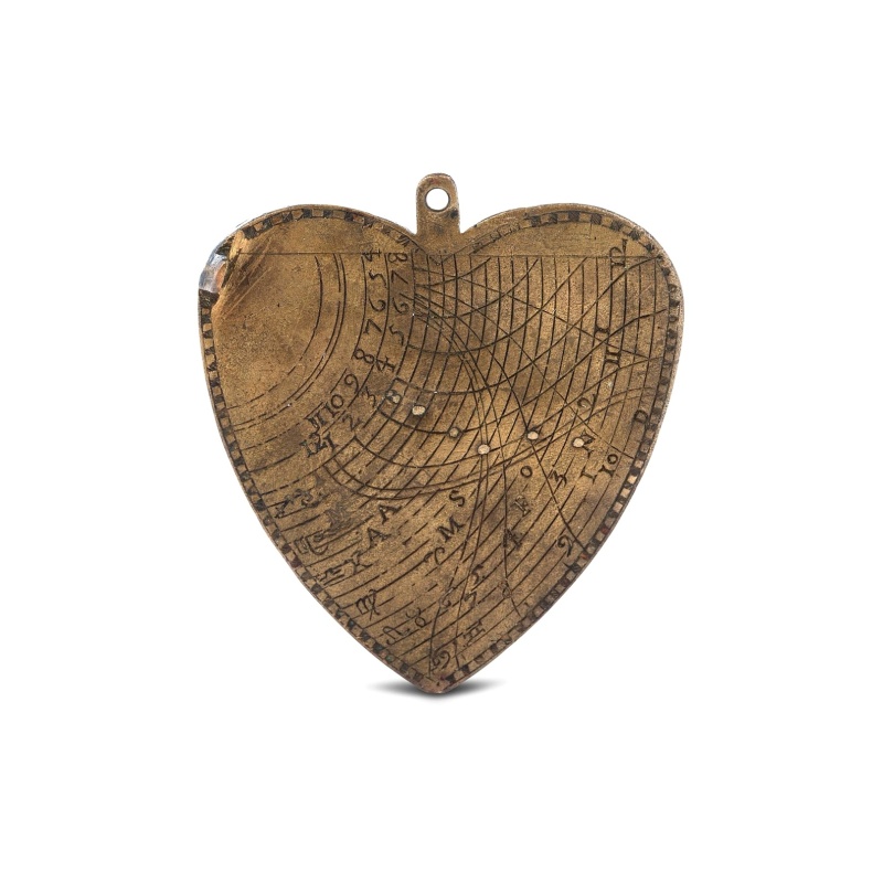
A cordiform - heart-shaped - horary quadrant marked with Gunter scales.
€7.166
- Quantity
- 1
- Postage
-
€0 to United States
Standard Shipping
Get Additional Rates
- Select Country
- Zip/Post Code
- Quantity
€7.166
81 watching
495 views
Description
A small and charming but very fine heart-shaped horary quadrant marked with Gunter scales. The scales are very finely engraved on both sides.
The quadrant was a very practical, functional, and portable instrument used for navigation. A horary quadrant is used to find the time of day by measuring the Sun’s altitude. As the quadrant became smaller and thus more portable, its value for navigation was soon realized. The first documented use of the quadrant to navigate at sea is in 1461, by Diogo Gomes.
Sailors began by measuring the height of Polaris to ascertain their latitude.
In 1618 English Mathematician Edmund Gunter further adapted the quadrant with an invention that came to be known as the Gunter quadrant.
The pocket-sized quadrant was revolutionary because it was inscribed with projections of the tropics, the equator, the horizon and the ecliptic. With the correct tables, one could use the quadrant to find the time, the date, the length of the day or night, the time of sunrise and sunset and the meridian.
The Gunter quadrant was extremely useful but had drawbacks; the scales only applied to a certain latitude.
Specifications
- Your stock number
- -
- Maker / Publisher
- ANONYMOUS
- Place
- ca. 1720-1760
- Date
- ca. 1720-1760
- Color
- Uncoloured
- Height
- 160
- Width
- 61
- Condition
- Brass. Good condition.
- Reference
- A Butterfield ring dial of similar design but smaller, is illustrated in Sundial at Greenwich, Hester Highton, OUP 2001, page 200, catalogue no. 186.
Payments & Returns
- Payment Methods
- Visa, Mastercard, Bank Transfer
Postage & Shipping
- Item Location
- Amsterdam, Alabama, United States
- Ships To
- United States, United Kingdom, Albania, Argentina, Armenia, Australia, Azerbaijan, Bahamas, Belgium, Bermuda, Cambodia, Canada, Chile, China, Croatia, Cyprus, Czech Republic, Denmark, Estonia, Finland, France, Germany, Gibraltar, Greece, Greenland, Guatemala, Hong Kong, Iceland, India, Indonesia, Israel, Italy, Japan, Latvia, Lithuania, Luxembourg, Malta, Mexico, Monaco, Netherlands, Norway, Singapore, Spain, Sweden, Switzerland, Turkey
- Pick-ups
- No pick-ups
- Returns Accepted
- No
Post Message
Sign in to ask the seller a question.
Paulus_Swaen
Kaart van de Gaspar Straaten volgens opnemingen van J.Stolze, D.Ross, enz.
Very large and rare chart centered on the strait between Bangka's southeastern seacoast and Belitung's western shores.Short front views of the coastal relief are shown in the lower-left corner of the map.The chart is prepared by H.L.Osthoff in 1840 and published in 1844 by Jacob Swart. When Gerard Hulst van Keulen died in 1801, his widow ran the firm until her death in 1810, at which time Johannes Hulst van Keulen became the last van Keulen to run the firm.In 1823, Jacob Swart entered the servic...
€806
Paulus_Swaen
Kaart van de Reede van Batavia met de verschillende vaarwaters naar dezelve trigometrisch opgenomen op last van deb schout bijnacht E.Lucas.
Very large and rare so-called blue-black chart centered on Jakarta's harbor.The chart is prepared by B.G.Escher, I.A.C. Eschauzier, B.H.Staring and E.H.Boom during an expedition in 1841 by the ships Krokodil and Hekla. The chart is engraved by J.C.Zurcher and updated for and published in 1847 by Jacob Swart. When Gerard Hulst van Keulen died in 1801, his widow ran the firm until her death in 1810, at which time Johannes Hulst van Keulen became the last van Keulen to run the firm.In 1823, Jacob S...
€1.612
Paulus_Swaen
Hollandiae Antiquorum Catthorum..
This map shows Holland in great detail, including small towns, walled cities, rivers and lakes (many of which were reclaimed in the 17th century, and no longer exist). A coat of arms is in the upper left corner of the map image. In the ocean, there are many sailing ships and smaller fishing boats. An intricate compass rose is in the upper middle area. A very decorative map of the Dutch provinces of Friesland, Groningen and Drente and of the German Province of Friesland.
€672
Paulus_Swaen
Pas-Caart van de Oost Zee verthooende alle de ghelegenheydt tusschen t Eylandt Rugen ende Wyborg. . .
An eye-catching chart of the Baltic Sea. Engraved by Gerard Coeck.Pieter Goos (ca. 1616-1675) was one of the most important cartographers, engravers, publishers and print sellers of Amsterdam. His widow continued business at her husband's death. She re-issued 'Nieuwe Groote Zee-Spiegel in 1676.The map is in a strictly contemporary coloring and of the highest level. Read more about exceptional map-coloring [+]
€1.344


-500x500.jpg)


